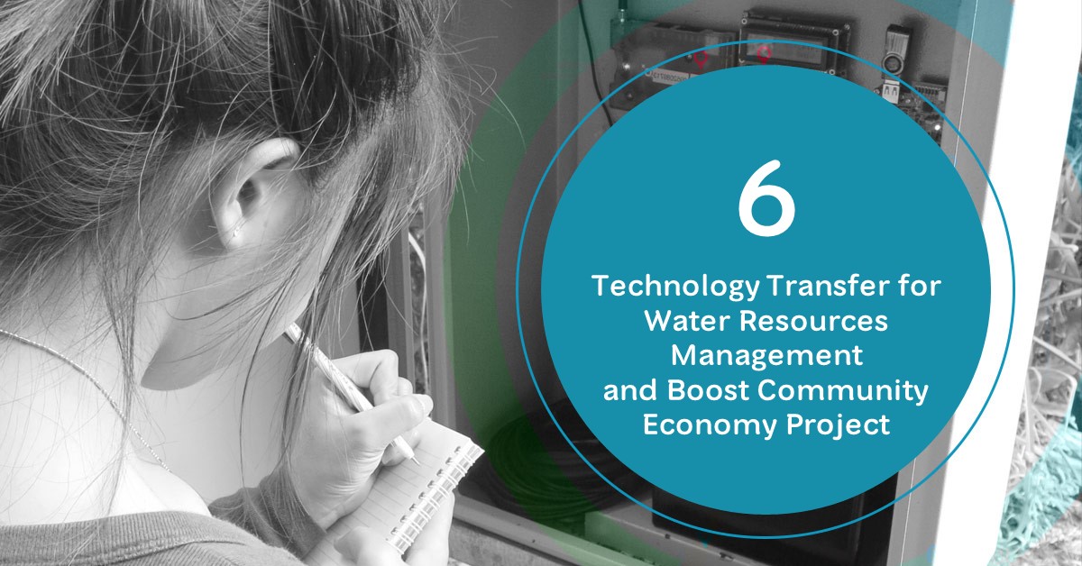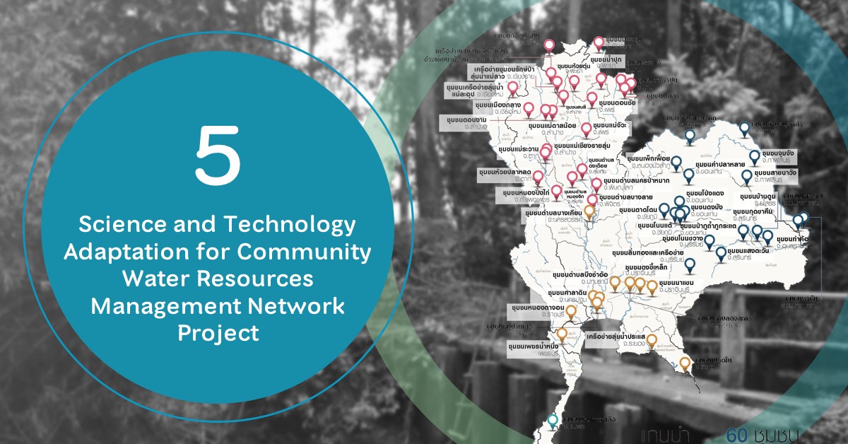
2018: Science and Technology Adaptationfor Community Water Resources Management Network Project
07/04/2020
Science and Technology Adaptation for Community Water Resources Management Network project has operated until 2018. In 2018 – 2020, HII has carried out the network assessment to strengthen local capacity in applying science and technology on water resource management, and ensure the result of the success was witnessed and applicable. Even though the project will be finished in 2020, the communities could still continue to expand their achievements to other communities for improving water resource management, research on the application of science and technology which will increase agricultural productivity and community economic value that leads to self-sustainability under normal-crisis situation and self-preparedness to tackle the changing climate.
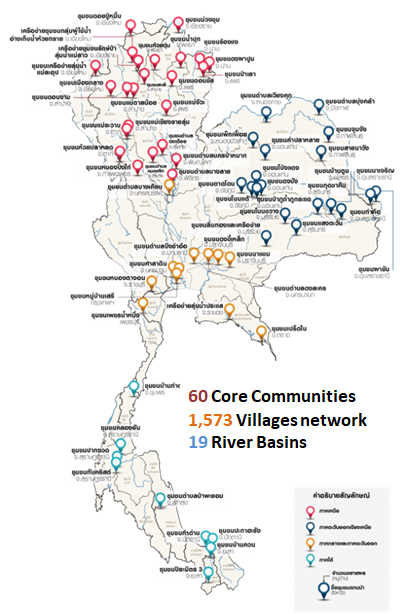
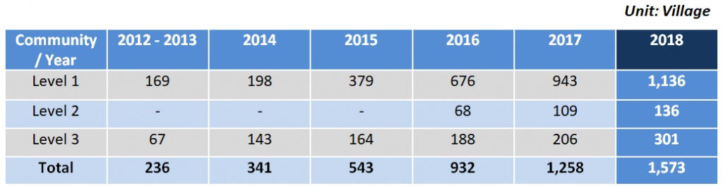
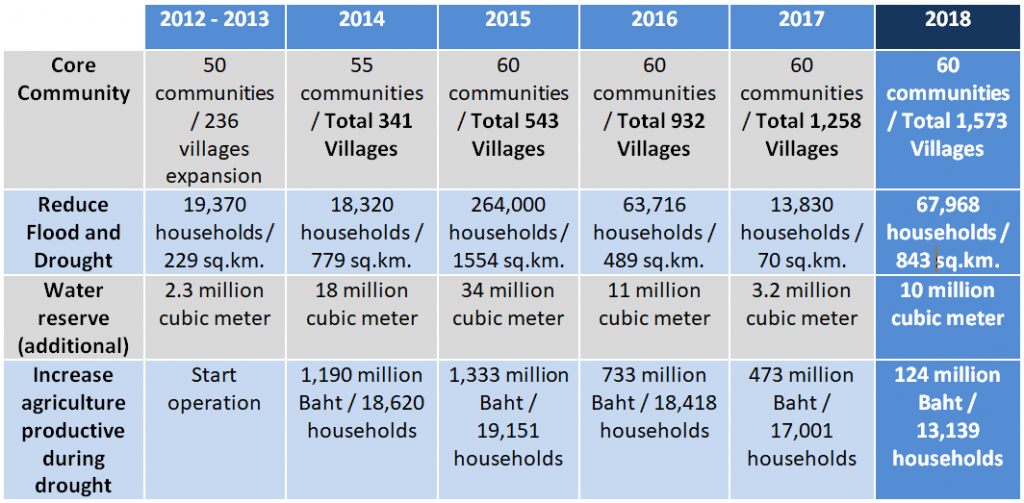
The result of project’s implementation from 2012 – 2018 can be evident by the expansion of the good practices to 1,573 villages, 19 live museums following H.M. King Bhumibol Adulyadej’s Initiative, 243 households covering 3.9 sq.km. has adopted the New-Theory Agriculture (Integrated Agriculture) concept. The Community Network can be classified into 3 levels as follows:
Level 1: Self-management on Water Resources
1,136 villages are self-developed and learned to manage local water resources following H.M. the King’s Initiative.
Level 2: Soil – Water – Forest, and Community Economy management
The communities could manage soil, water, and forest resources, apply Three Forest, Four Benefits concept, and shift their cultivation pattern to New-Theory (Integrated Agriculture) concept. This regards, the community should create their own crop calendar which align with the changing climate, have cooperation in Co-analysis, Co-production, Co-selling which allow them to have constant production and revenue year-round for 136 villages.
Level 3: The Sustainable Community Network and its Expansion
The collaborated communities act as a model of good practice on soil, water, forest management, and New-Theory Agriculture and continuously promoting their models to achieve the sustainability concept to other 301 villages.
In 2018, the network has expanded new theory agriculture to 243 households, decreased household expenditure for 4.7 million baht/year, increased household income for 10.75 million baht/year, increase productivity during dry season for 8,829 households and avoid flood risk for 4,310 households. The total achievement is 1) increase cultivation value for 124 million baht, 2) reduce flood risk for 67,968 households, benefit to 900 sq.km. of agricultural areas, and increase water reservation capacity of 10 million cubic meters.
Example: Good Practice in Sai Na Wang sub-district, Na Koo district, Kalasin Province
Sai Na Wang community has been facing water scarcity and connectivity of sources of water reservation for more than 38 years, though the community itself surrounded by 2 old brooks, Sai Na and Ma No brook, which were built since Dhavaravati period (around 16th century). The two brooks are still in good condition because of the maintenance and protection of local community. The distance of 10 kilometres around the city has increased water capacity for 300,000 cubic meters which is sufficient for 23 sq.km. of agricultural area in Sai Na Wang Sub-district.

Past: Sai Na Wang Sub-district community has faced flash flood and flood events 
Past: Sai Na Wang Sub-district community has faced drought events
Sai Na Wang community has applied science and technology adaptation for water resource management to set the local water resources improvement guideline by surveying their area to define geographical conditions, data gathering by using satellite maps and GPS receiver, analysis and create Geographic Information System (GIS). The community set up a working group for monitoring, maintenance, and managing water resources according to the local sociocultural needs, also adopted His Majesty King Bhumibol Adulyadej’s guideline in repairing canal, connecting water channels, increase security for New-Theory Agriculture and increase household food and income security.
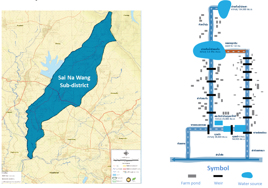


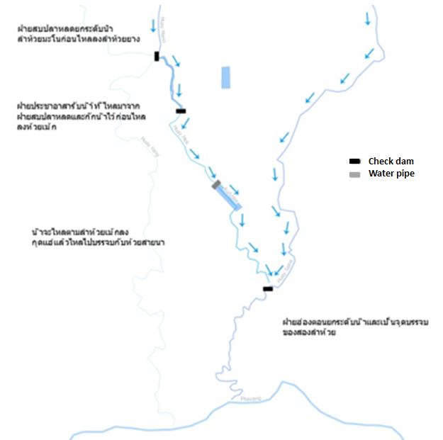
The community has managed 15 weirs along Sai Na and Ma No brook to retard water flow and store flood in the brook for agriculture during dry season. Each reservoir is rehabilitated with wooden watergate for balancing water level in different reservoirs, which was overseen by Sai Na Wang Community Water Resource Management Committee. This method increased 176,750 cubic meters of water per year and distributed water to 8 villages, 3.36 sq.km. of agricultural area, 300 households, and 900 people.

Water flow from Sob Plalod weir into Huay Yang brook and flow into Lam Phayang 
Water flow from Sob Plalod weir into Huay Yang brook and flow into Lam Phayang
Moreover, the community has applied “Pond Network” (Ang Poung) concept by connecting 300 reservoirs and local brooks which increased 6.47 million cubic meters of water, covering 24 villages 1,337 households, 3.32 sq.km. in Sai Na Wang sub-district.

Most of farmers in Sai Na Wang sub-district mainly practice monoculture which is costly, lead to higher debt, and eventually loss of land. Therefore, they have shifted to integrated agriculture and restore the water system, pond network, adopt new-theory agriculture. This change is aligned with the community agricultural style which focuses on self-reliant, minimize expenditure, maximize productivity and income.
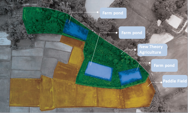
At present, there are 28 farmers have shifted their cultivation pattern to follow new theory agriculture by adjusting farmland, irrigation system and cultivation plan. They have now expanded their good practices to other 30 local farmers. Therefore, the total number of 58 farmers have increase their income of 7,000 baht/ household/ month or totally 4,872,000 baht/ year and reduce the household expenditure of 2,000,000 baht/year.
Internal water resources management in cultivation areas minimize the risk of water scarcity, sustain water and food supply, generate income, reduce expenditure and self-sustainable/reliable